

National Geographic Trails Illustrated Map Carlsbad Caverns National Park - 9781566954891
Un libro in lingua di Not Available (NA) edito da Natl Geographic Maps, 2007
- € 9.60
- Il prezzo è variabile in funzione del cambio della valuta d’origine
• Waterproof • Tear-Resistant • Topographic Map
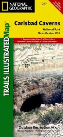
This two-sided map shows two worlds - the beautiful landscape in and around Carlsbad National Park and Wilderness area on one side, with the other side showing detail and trails in one of the world's most fascinating and accessible underground wonders. Above ground, the map includes Carlsbad Caverns National Park and Wilderness, portions of Lincoln National Forest, and the surrounding area. Hiking trails include Chihuahua Desert Nature Trail, Old Guano Road Trail, Rattlesnake Canyon Trail, Guadalupe Ridge Trail, Slaughter Canyon Trail and Slaughter Canyon Cave Trail, Yucca Canyon Trail, Usery Trail, and Rock Shelter Trail. The Caverns map features detailed trail information for both guided and self-guided tours, including detail that shows stalactites, stalagmites, columns, breakdowns, slopes, pools, bat guano, gypsum, and unexplored passages. Includes UTM grids for use with your GPS unit.
- Sheet Size = 37.75 x 25.50
- Folded Size = 4.25 x 9.25
- Scale = 1:35,000
Informazioni bibliografiche
- Titolo del Libro in lingua: National Geographic Trails Illustrated Map Carlsbad Caverns National Park
- Lingua: English
- Autore: Not Available (NA)
- Editore: Natl Geographic Maps
- Collana: Natl Geographic Maps (Paperback)
- Data di Pubblicazione: 01 Gennaio '07
- Genere: Lingua Inglese
- Pagine: 2
- Dimensioni mm: 234 x 120 x 6
- ISBN-10: 1566954894
- EAN-13: 9781566954891