

National Geographic Trails Illustrated Map Old Forge / Oswegatchie, Adirondack Park - 9781566954198
Un libro in lingua di Not Available (NA) edito da Natl Geographic Maps, 2004
- € 9.60
- Il prezzo è variabile in funzione del cambio della valuta d’origine
• Waterproof • Tear-Resistant • Topographic Map
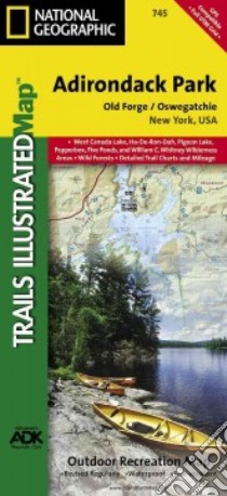
National Geographic's Trails Illustrated map of Adirondack Park Old Forge/Oswegatchie is a two-sided, waterproof, topographic trail map designed to meet the needs of outdoor enthusiasts with unmatched durability and detail. This map was created in cooperation with the Adirondack Mountain Club and is loaded with valuable recreation information, no matter the season. Trails and major roads are clearly distinguished, along with canoe access and snowmobile trails. Places of interest, including the Cranberry Lake 50 Trail, campgrounds, and fishing easements, are labeled and easy to find. The map also features color coded boundaries for parklands, primitive, forest, and private property. Discover the Adirondack's wild, rugged and beautiful terrain, with detailed elevation contours, shaded relief, vegetation, and water features.
Map coverage includes western and southwestern Adirondacks, including Five Ponds Wilderness, William C. Whitney Wilderness, Round Pond Wilderness, Pepperbox Wilderness, Ha-de-ron-dah Wilderness, Cranberry Lake Wild Forest, Black River Wild Forest, Independence River Wild Forest, Aldrich Pond Wild Forest, Sargent Ponds Wild Forest, Horseshoe Lake Wild Forest, Watsons East Triangle Wild Forest, and Grasse River Wild Forest. A Western Trail Chart inset, along with UTM grids for use with your GPS unit and a trail mileage matrix, keep you on course.
The Adirondack Park Old Forge/Oswegatchie map is designed and printed in the United States on durable synthetic paper, making it waterproof, tear-resistant, and trail tough – made to head outside and go anywhere you do. The map is two-sided, and is folded to a packable size of 4.25" x 9.25"; unfolded size is 26" x 38".
Key Features:
• Waterproof and tear-resistant
• Updated regularly
• Designed and printed in the U.S.A.
• Detailed road network, including designations for off-highway roads
• Clearly marked trails for hiking, canoeing and more
• Detailed topography with shaded relief and clearly defined, color-coded boundaries for parks, recreation areas, wilderness areas, forest and primitive areas.
• Hundreds of places-of-interest, including campgrounds, information centers, boat launches, canoe carry downs, fishing access points, ski areas, and specialty content unique to each area
• UTM and Latitude/Longitude coordinate grid, as well as selected waypoints, and a scale bar for easy and accurate navigation.
All National Geographic trail maps contain helpful information on local regulations, safety, important contact information, and park interpretive content.
Net proceeds from the sale of this map go to support the nonprofit mission of the National Geographic Society.
- Sheet Size = 25.50 x 37.75
- Folded Size = 4.25 x 9.25
- Scale = 1:75,000
Informazioni bibliografiche
- Titolo del Libro in lingua: National Geographic Trails Illustrated Map Old Forge / Oswegatchie, Adirondack Park
- Lingua: English
- Autore: Not Available (NA)
- Editore: Natl Geographic Maps
- Collana: Natl Geographic Maps (Paperback)
- Data di Pubblicazione: 01 Gennaio '04
- Genere: Lingua Inglese
- Pagine: 2
- Dimensioni mm: 228 x 107 x 6
- ISBN-10: 1566954193
- EAN-13: 9781566954198