

National Geographic Trails Illustrated Map Weminuche Wilderness - 9781566952910
Un libro in lingua di Not Available (NA) edito da Natl Geographic Maps, 2011
- € 9.60
- Il prezzo è variabile in funzione del cambio della valuta d’origine
• Waterproof • Tear-Resistant • Topographic Map
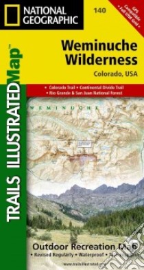
Coverage includes San Juan and Rio Grande national forests; Weminuche Wilderness; Williams Creek; Big Meadows and Rio Grand reservoirs; Chicago Basin, Emerald, and Electra lakes; Wagon Wheel Gap, Wolf Creek, and Rockwood. 14ers: Sunlight Peak, Windom Peak, Mt Eolus; Piedra, Squaw and Molas passes; San Juan Mountains; San Juan, Rio Grande and Los Pinos rivers. Ski Area: Wolf Creek. Includes portions of the Continental Divide Trail and the Colorado Trail. Includes UTM grids for use with your GPS unit.
- Sheet Size = 25.50 x 37.75
- Folded Size = 4.00 x 7.50
- Scale = 1:63,360
Informazioni bibliografiche
- Titolo del Libro in lingua: National Geographic Trails Illustrated Map Weminuche Wilderness
- Lingua: English
- Autore: Not Available (NA)
- Editore: Natl Geographic Maps
- Collana: Natl Geographic Maps (Paperback)
- Data di Pubblicazione: 01 Gennaio '11
- Genere: Lingua Inglese
- Pagine: 2
- Dimensioni mm: 190 x 107 x 12
- ISBN-10: 1566952913
- EAN-13: 9781566952910